
Antarctica is more than five million square miles of vast, frozen ice and rock marked by bone-freezing temperatures, high winds, no running water and few signs of life. But what it lacks in accommodations, it makes up for in something important to the rest of the world: Information.
While other parts of the world’s landscape have evolved, Antarctica’s polar temperatures and ice have stopped the ground in its tracks, offering researchers a goldmine of insight into the history of our planet, which might indicate what could happen in the future.
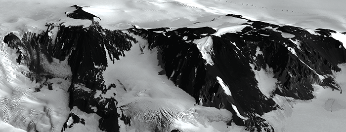
Terry Wilson, Ph.D., is an Ohio State professor in the School of Earth Sciences whose research group investigates the structural architecture of the Earth. One of her recent projects harnessed the Ohio Supercomputer Center’s (OSC) Oakley Cluster to use high-resolution Digital Elevation Modeling (DEM) data to perform morphometric analysis—an analysis of form, encompassing size and shape—of the Erebus Volcanic Province in Antarctica.
“Monitoring landscape change over time is integral to an understanding of Earth surface processes as they pertain both to society and to the natural world,” Wilson said. “Rivers and glaciers are dominant agents of erosion, and much research is aimed at determining the rates of fluvial and glacial erosion and how these relate to landscape change. Polar glaciers, or cold-based glaciers frozen to their bed, are considered to be ineffective agents of erosion and, in Antarctica, it has been suggested that mountain landscapes have been preserved with little change over nearly 14 million years in the prevailing polar desert environment.”
However, erosion rates in polar regimes have not been extensively studied. Wilson’s group focused on cinder cones – small volcanoes that erupt around larger volcanoes or areas where the ground is undergoing stress.
“Cinder cones are helpful because they form as a structure consistently, not necessarily the same size but the same slope, the same height-to-width ratio,” said Andrew Collins, a graduate student. “So if you’re studying geomorphology, cinder cones in that nice controlled shape act as a control on your hypotheses.”
Two questions the project sought to answer were: Do cinder cones show a slow, systematic change in a polar desert environment and whether cold-based glaciation actually affects the shape of cinder cones and other landforms over time.
“The over-arching question is whether we can actually predict the age of cinder cones based on their shape, because they presumably degrade over time in a predictable way,” Collins said.
Information about cinder cones will give insight into many different processes within Earth’s crust. For example, under tectonic stress, cones can form in areas of crustal weakness near plate boundaries and actually be elongated on the surface by the powerful stresses below it. That indicates which plates were pushed together, how hard and from what direction.
“That helps us understand not only elements of the climate, but also shallow crust and potentially even deeper crust processes over time,” Collins said.
Because the project location was Antarctica, there were many logistical challenges of field work, meaning much of the work was performed digitally. Collins used algorithms developed by other researchers to run high resolution imagery through the Oakley Cluster to create 3D models that help parameterize and compare cinder cones.
“OSC was huge, most of this work was done digitally through satellite stereo imagery to build these spectacular high resolution DEMs,” Collins said. “The takeaway point is what happened in the past will continue to happen in the future. Also, it validates this particular method of remote sensing. This is a rapidly expanding field and this project demonstrates how viable this approach is and how valuable it can be.”
###
Written by Ross Bishoff
Project Lead: Terry Wilson, Ph.D., The Ohio State University
Research Title: Morphometric analysis of Erebus volcanic province, Antarctica, using high-resolution DEM data
Funding Source: The Ohio State University
Website: earthsciences.osu.edu/people/wilson.43