Visualizations will allow students with mobility impairments to explore caves
Columbus, Ohio (Aug. 17, 2011) – College students with mobility impairments who are studying for a career in the geosciences will soon be able to explore a computer-generated simulation of a large cave system to meet the degree requirements of field-based learning experiences.
 |
| Don Stredney |
 |
| Christopher Atchison |
 |
| Thomas Kerwin |
To develop an interactive, virtual field trip through a portion of Kentucky’s famous Mammoth Cave, the National Science Foundation (NSF) Opportunities for Enhancing Diversity in the Geosciences (OEDG) Program has provided funding for a research team led by a team of visualization experts at the Ohio Supercomputer Center (OSC) and a geoscience researcher at Georgia State University (GSU).
Mammoth Cave is the world’s longest known cave, with more than 392 miles (630 km) of interconnected chambers and passages. The cave began forming around ten million years ago, as water slowly eroded the thick Mississippian-aged limestone strata lying beneath a cap layer of sandstone. Mammoth Cave National Park was established in 1941 to preserve the elaborate cave systems and protect unique plants and animals found above and inside the caves.
The two-year proof-of-concept research project, “Expanding Geoscience Diversity through Simulated Field Environments for Students with Physical Disabilities,” seeks an alternative environment to the physically demanding conditions encountered during field study, conditions that have led to a an underrepresentation of graduates with mobility impairments in the geosciences.
“Traditionally performed outside of the laboratory, geology is the study of the interrelationships between the natural processes that have shaped the earth over billions of years,” said Christopher L. Atchison, Ph.D., recently a graduate research assistant at OSC and now an assistant professor of geoscience education at GSU. “Although there are many sub-disciplines within the geosciences that create different opportunities, this science does not lend itself well to those who are physically unable to venture past the controlled laboratory setting.”
In addition to structural data the research team previously obtained from the Cave Research Foundation, they also will gather high-precision data collected by laser remote-sensing technology, called LIDAR (Light Detection And Ranging), and through high-resolution digital photography of specific geological formations needed for the training.
The data will be integrated into a virtual environment to emulate a typical field outing that will then be explored and evaluated for usability by a representative group of students with mobility impairments selected and supported by Ohio’s STEM Ability Alliance. To test the effectiveness of the virtual experience, the research team will place the students in the various environments and evaluate their ability to convey their understanding of the content through questions asked during the simulation, as well as online surveys conducted immediately following the simulation sessions.
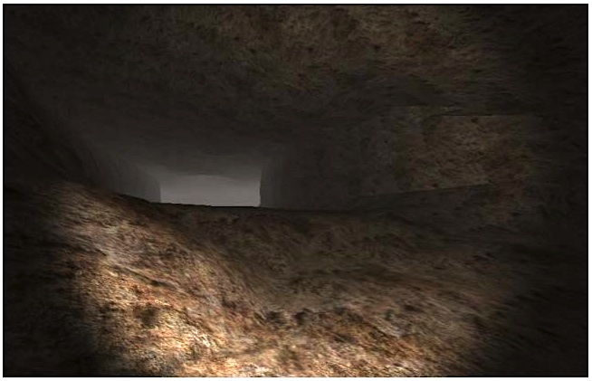 |
| A screenshot shows a preliminary simulation of a portion of Mammoth Cave. The simulation was part of a planning study at OSC that resulted in additional NSF funding to further develop the virtual cave system to help college students with mobility impairments pursue a career in the geosciences. (Credit: Ohio Supercomputer Center) |
 |
| Several students with mobility impairments are led through Mammoth Cave by Christopher Atchison, Ph.D., an assistant professor of geoscience education at Georgia State University. An NSF-funded study at OSC aims to further develop a virtual cave system to help college students with mobility impairments pursue a career in the geosciences. (Credit: C. Atchison) |
“Through this experience, students will better inform the creation and development of a synthetic environment tailored to emulate a geological field study,” explained Don Stredney, OSC senior research scientist for biomedical applications and director of the center’s interface laboratory. “Additionally, the students’ experiences will assist the developers in creating an environment that is tailored to their abilities, as well as in establishing a sense of realism based on their experiences within the actual field site.”
In developing a very basic simulation demo for an earlier planning study, the team processed a polygon mesh model to make it compatible with a freely available 3-D gaming engine. Following the application of texture maps to the mesh, a player-controlled camera with a headlamp was added to the program. The research team designed the final demo to be run as a stand-alone program or in a web browser on both Windows and Macintosh computer platforms.
By working with the content experts, the research team will develop interactions within the virtual environment to allow users to call up additional information about the cave and karst system. A karst is an area of irregular limestone that has been eroded to produce fissures, sinkholes, underground streams and caverns.
“Information, such as high-resolution photos, web pages, diagrams and GIS resources, can be integrated into the module,” said Thomas Kerwin, Ph.D., a research scientist at OSC working on the simulation development and a recent graduate in computer science at The Ohio State University (OSU). “Audio narration also can be added to create a user-friendly, autonomous method of navigating the virtual environment.”
The interdisciplinary research effort includes individuals with expertise in modeling and simulation, virtual environments, human factors, geosciences and teaching and learning. The team will be collaborating with members of the Mammoth Cave International Center for Science and Learning, OSU’s Advanced Computing Center for the Arts and Design, the OSU School of Teaching and Learning, the National Cave and Karst Research Institute, the Cave Research Foundation, Ohio’s STEM Ability Alliance and the International Advisory for Geoscience Diversity.
The team hopes that the project will prove the vast potential for a simulated field experience and lead to an even broader, more involved OEDG full-scale study of a virtual field education module.
This material is based upon work supported by the Opportunities for Enhancing Diversity in the Geosciences Program of the Directorate for Geosciences of the National Science Foundation under grant no. GEO-1108127. Any opinions, findings, and conclusions or recommendations expressed in this material are those of the author(s) and do not necessarily reflect the views of the National Science Foundation.
The Ohio Supercomputer Center OSC) addresses the rising computational demands of academic and industrial research communities by providing a robust shared infrastructure and proven expertise in advanced modeling, simulation and analysis. OSC empowers scientists with the vital resources essential to make extraordinary discoveries and innovations, partners with businesses and industry to leverage computational science as a competitive force in the global knowledge economy, and leads efforts to equip the workforce with the key technology skills required to secure 21st century jobs. For more, visit www.osc.edu.
Georgia State University is the Southeast's leading urban research institution. It is on the list of the top 100 public universities for doctoral degrees awarded. More than 250 degree programs within 62 areas of study are offered at the bachelor's, master's, specialist and doctoral levels. Students may enroll in day or evening classes and in part-time or full-time study. For more, visit www.gsu.edu.