A detailed understanding of the Earth’s land topography is critical to those in geosciences, geographical sciences and even civil engineering. The datasets associated with our land surface topography are the key ingredient to everything from urban planning to plate tectonics.
One of the key tools in this process are Digital Elevation Models (DEMs), which are 3D representations of land surfaces that provide information on a wide range of scientific, navigational and engineering activities. While these models are highly accurate in most areas of the globe, high-latitude, mountainous areas covered in snow and ice have been a challenge to map.
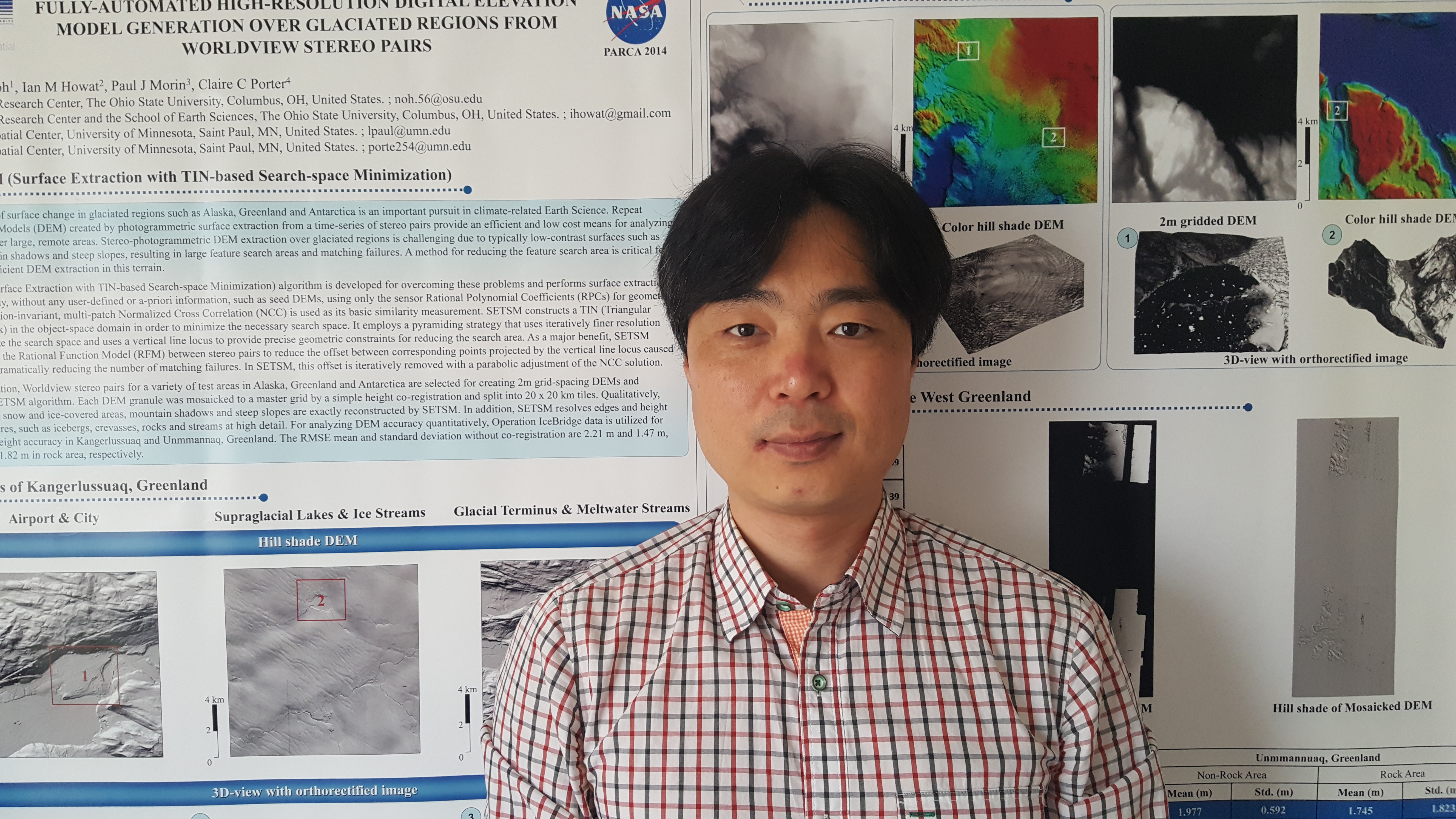
In order to meet this challenge, Ian Howat, Ph.D.–professor at The Ohio State University’s School of Earth Sciences Department and Director of the Byrd Polar and Climate Research Center—and Byrd Center Senior Research Associate Myoung-Jong Noh, Ph.D., have developed a tool that will accurately produce DEMs of Arctic and Antarctic terrains.
With high performance computing resources from the Ohio Supercomputer Center, Howat and Noh developed the Surface Extraction from Tin-Based Search Minimization (SETSM) algorithm to accurately generate DEMs of these areas.
“The effort was motivated by the fact that no existing commercial or open-source DEM extraction software supports fully automated processing,” Howat said. “We’ve spent years developing SETSM for constructing photogrammetric DEMs from satellite imagery with the objective of creating a fully automated system capable of handling large amounts of data.”
DEMs are generated by using satellite images to detect corresponding points between two images taken at different positions, similar to how human eyes have slightly different perspectives. The information is then computed as a 3D coordinate from a sensor model that explains the relationship between a flat image and the Earth’s surface.
A step in finding the corresponding points is aligning the pair of images through pattern matching. DEMs are dependent on the accuracy of the image matching algorithm and the sensor model. Traditionally, image matching was done by hand, a procedure far too laborious for a high volume of data. Development of a fully automatic DEM generation software is therefore critical for application to large-scale datasets.
“It’s especially important in the Arctic and Antarctic,” Noh said. “High-quality stereoscopic DEM extraction over mountainous, snow-covered and glaciated regions is particularly challenging due to the prevalence of low-contrast surfaces such as ice, snow and mountain shadows and repetitively patterned textures.”
Noh and Howat used OSC clusters to develop and test SETSM to speed up the procedures with various datasets. The project began in 2012 and in 2015 SETSM became a main DEM-producing software. In 2017, it was released as an open source code. SETSM is the DEM extraction software used for the National Science Foundation’s major surface mapping projects; ArcticDEM and the Reference Elevation Model of Antarctica, which are providing the first continental-scale topography datasets at high resolution.
“OSC does a great job of supporting researchers who need rapid processing,” Noh said. “The DEMs generated by the SETSM algorithm can be applied to large data sets for a wide range of applications requiring detailed topographic information for mapping, land classification and change detection. In 2015, for instance, the SETSM team that included OSC worked quickly to produce high resolution elevation models for the Nepali earthquake relief effort. These data were critical for a range of uses, including mapping infrastructure, planning rescues and assessing slope stability.”
Project Lead: Ian Howat, Ph.D., Professor, Director of Byrd Polar and Climate Research Center, Myoung-Jong Noh, Ph.D., Senior Research Associate, School of Earth Sciences, The Ohio State University
Research Title: Collaboration on SETSM Software
Funding Source: U.S. National Aeronautics and Space Administration, U.S. National Science Foundation, Polar Geospatial Center
Website: https://earthsciences.osu.edu